
Since it was a nice sunny day it was my plan to stop everywhere for photos. After I left home and headed north down Cambie Street I noticed a nice view of the City and I was lucky to snag a parking spot

It was not that early but being a Saturday, the traffic was light.

I zoomed in on the "Lions" in the background (info here) Those are part of the North Shore mountains. Vancouver is surrounded by mountains: Hollyburn, Cypress, Grouse and Seymour Mountains are to our north. We were always taught that the Mountains are North, so you can always determine where you are by looking at them
I snaked my way through the Downtown area and found myself going over the Lion's Gate Bridge

During rush hours, this is a bottleneck and we only have two bridges which cross over Burrard Inlet. Three lanes is not enough and during rush hours they change to two lanes either south or north depending upon traffic conditions. Notice the traffic arrows above
After a relaxing BBQ lunch at this place where they (ScooterChick and Scootard) had never eaten before

We went our separate ways. Little did I know they were coming down to Vancouver but I decided to navigate over to their Beach area

There is lots of undeveloped land in Squamish

and I stopped several times to grab some photos along the way. I even made it to the famous sandy beach in Squamish but it was very windy there and I was getting chilled. I had originally wanted to wade in the water but it was a good day for all the windsurfers that I saw

Notice that angy tree trunk on the right which was stareing at me. Soon it was time to go so I headed south

on Hwy99 and headed for Whytecliff Park. I like it there as I wanted to show you the little island
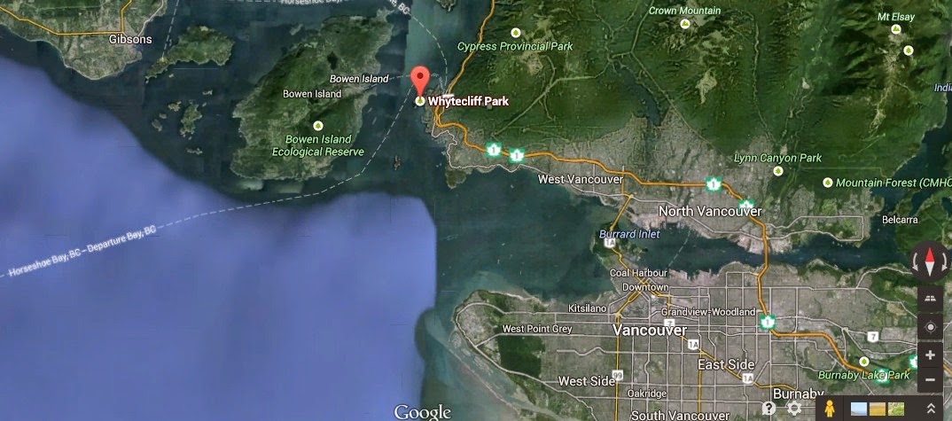
It is not far from Vancouver and it is a nice ride along Marine drive with lots of water views along the way to Horeshoe Bay. Look at the map below. Notice the little Island which is cut off from land during

high tide

There always seems to be people walking back and forth from the Island but the rocky bridge is below water during high tide, which is twice a day. If you make it over you may be stranded over there for half a day before you can walk back

It is hard to walk barefoot as there are lots of rocks and gravel

but I manage to fit in a bit of wading action.

I decided to take a rest break and just enjoy the day. During warmer days it is a challenge to find parking here as there are only two parking areas and if full, there is no where else to park. The road is a narrow shelf road along rock-faced walls barely wide enough for two cars to pass
As I approached the Lion's Gate bridge I was caught for about half an hour in traffic congestion. That's how long it took to go two miles before I could actually reach the bridge deck towards Stanley Park

There could be a mile of traffic behind me and I was only about half the way

I made one more stop at False Creek to aim my lens directly into the sun to see how much flare I would get. The photos above were taken on 12April2014. Hard to believe that nearly a month has passed and that was before when I was able to walk
Fast forward to today
Today is Sunday, Haircut day. At least I still have some left to cut but it is getting a bit sparse

My barber is as close as our kitchen

I hope I still have some left when the procedure is done. I am crying inside
That little island is a pretty cool feature to have so close to town. The traffic and parking in Vancouver sound miserable. Too much of one and not enough of he other.
ReplyDeleteThe haircut photo is one of the better self portraits I've seen of you.
Richard:
DeleteI like that island. it is so photogenic, esp on a nice warm summer's day.
I'm lucky that I can still have a haircut. Soon it will be head polish to keep it shiney
I bet Yvonne takes good care of you when she trims your hair. Did you at least tip her?
ReplyDeleteThanks for sharing all the Lower Mainland pics. Is Squamish still considered lower mainland?
Trobairitz:
DeleteI'm spoiled. Her mother used to be a hair dresser so she bought barber stuff years ago and I haven't had to pay for a haircut since (a long time ago).
I have always considered the Lower Mainland to be the delta areas, lowland which stretch from the ocean all the way to past Chilliwack. In other words, the flat lands. Squamish is just north in the mountainous areas of Howe Sound so technically it isn't in the Lower Mainland, the way I imagine, just like the wikipedia definition
http://en.wikipedia.org/wiki/Lower_Mainland
which includes the Fraser Valley (to as far as Hope, BC)
I too like the pic of the island that is isolated by tides twice a day....the traffic pics, I can do without. Lovely shots of the mountains to the north....we're told to look for mountains to determine where West is....
ReplyDeleteDom:
DeleteYou got a small taste of our traffic when you were here last year. It probably took you nearly an hour to get to Sonja's. Every time I think about the open road, I think about the hour it takes to get there.
Up here the Mountains signify North. We only have one road north of Vancouver. The other road which goes north is 3 hours East which goes up the Fraser Canyon. We have too many mountains in our way.
I do like that island but you can't get near Whytecliff Park during the warmer weather due to lack of parking
Squamish looks like my kind of city. Small, beautiful, and surrounded by snow-capped mountains. If I HAD to choose a city in which to live, which I hope I never have to do, I'd want that kind of surroundings. Great pics!
ReplyDeleteKathy:
DeleteSquamish is a nice little town but there is only one road North or South which gets clogged all year around. Skiers in Winter going to Whistler, and tourists during the Summer. The road is always busy with aggressive traffic. I keep thinking about that gravel road to your WV cabin so you live in a less populated place too. I hope to see it one day . . .
Beautiful mountains. We have the traffic controlled bridges here as well.
ReplyDeleteKaren:
DeleteYou have beautiful backroads too. They are not like ours which snake their way through valleys and mountains. Those are part of our Coastal Mountain Range and once you get on the other side, the climate turns more arid with much higher temperatures. I know how much you like mountainous riding.